


davalada

lablaquiere
User
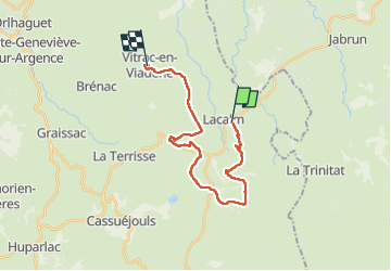

Length
21 km

Max alt
1220 m

Uphill gradient
359 m
Km-Effort
27 km

Min alt
989 m

Downhill gradient
495 m
Boucle
No
Creation date :
2022-10-09 07:23:14.901
Updated on :
2022-10-09 14:28:49.908
4h35
Difficulty : Very difficult

FREE GPS app for hiking
 SityTrail
IGN / Geographical institutes
SityTrail Plus
The world is yours!
About
Trail Walking of 21 km to be discovered at Occitania, Aveyron, Argences en Aubrac. This trail is proposed by lablaquiere.
Positioning
Country:
France
Region :
Occitania
Department/Province :
Aveyron
Municipality :
Argences en Aubrac
Location:
Lacalm
Start:(Dec)
Start:(UTM)
491088 ; 4957526 (31T) N.
Comments